Ludgate Hill, London An evocative photograph of St. Paul’s Cathedral, taken from Ludgate Hill. It was taken on December 29th 1940 at the height of the bombing of London during World War 2. Taken in the evening, with no artificial light, St. Paul’s is seen surrounded by the fires caused by German bombs. In the foreground, many vehicles containing fire crews are seen heading towards the fires. To the left of the photograph is the glow of fires in the Paternoster Square and Cheapside areas. To the right is the area between St. Paul’s and the Thames. Image: ©Mirrorpix In August 2020 – 80 years later – the scene is very peaceful, and greener than in 1940. London is still in the grip of COVID-19 which explains the absence of tourists. Image: © Steven Miell (TimeViews) A merged version of the two photographs. Use the slider in the centre.
Chingford Hatch, London Chingford Hatch shopping arcade in 1949. Dominated by the Enfield Highway Co-operative Society Ltd. The absence of cars is apparent.Image: Photographer unknown From the same position at the start of the Coronavirus pandemic (March 26 2020). The Co-Op was full of customers but reasonably well stocked.Image: © Steven Miell (TimeViews) A merged version of the two photographs. Use the slider in the centre.
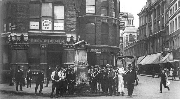
Bank, London The frontage of the Bank of England, with the pillars of the Royal Exchange building on the right. The photograph was taken in 1951. Image: Photographer unknown The same view in March 2021.Image: © Steven Miell (TimeViews) A merged version of the two photographs. Use the slider in the centre.
Covent Garden, London This photograph was taken in 1974 during the last days of the market in Covent Garden. At the time, there was a debate about whether the central buildings (to the left of the photograph) should be demolished or not. Image: Photographer unknown By September 2020, the area is now firmly entrenched as a tourist destination. Image: © Steven Miell (TimeViews) A merged version of the two photographs. Use the slider in the centre.
Agincourt Square, Monmouth Taken from an old postcard, this view of the King’s Head Hotel in Agincourt Square in Monmouth was taken in (I assume) the 1920s. The hotel stands opposite the Shire Hall (to the left of the photograph) and dates from the middle of the 17th century. According to legend, the hotel was visited by Charles I in 1645. It was an important posting inn in the late 17th century, with space for the stabling of visitors’ horses. During the 18th and 19th centuries, stagecoaches for London left from here. It is now a Grade II listed building.As mentioned above, Charles I was reported to have visited the hotel in 1645 during a stay at nearby Raglan Castle. There is a plaster bas-relief of the King (erected in 1673) above the fireplace in one of the bars. Whether it is meant to be Charles I, or a generic ‘king’ is disputed. Image: Photographer unknown took this photograph in March 2020, just before the COVID-19 lockdown started. Image: © Steven Miell (TimeViews) A merged version of the two photographs. Use the slider in the centre.
Monnow Street, Monmouth A view from Monnow Street in Monmouth towards Monnow Bridge – the last remaining fortified river bridge in the country. The fortification is a Grade I listed building. Monmouth was an important border settlement in Roman times (Blestium). However, it seems that the River Monnow did not have a crossing until some time after the Norman conquest. It appears that construction of a Monnow Bridge began in 1272 – this to replace a Norman timber bridge. Over the years, the Monnow Bridge has been used as a jail, a store for munitions, and a toll bridge – among other uses. Tolls were collected through control of the points of entry to the town, including the gatehouse on the bridge.The bridge was built of red sandstone and was substantially rebuilt in the 18th and 19th centuries. Heavy traffic use and subsequent damage in the 20th century, together with the building of another bridge, allowed this bridge to be pedestrianised. This photograph was taken in the 1910s. Image: Photographer unknown (1910s) From approximately the same position in March 2020. Image: © Steven Miell (TimeViews) A merged version of the two photographs. Use the slider in the centre.
Victoria Embankment, London A number 62 tram (destination, Dulwich) is seen on Victoria Embankment (opposite Embankment tube station) in 1935. Image: London Metropolitan Archives (City of London Corporation) The same view in March 2017. Image: © Steven Miell (TimeViews) A merged version of the two photographs. Use the slider in the centre.
Oxford Circus, London A view of Oxford Circus – taken from Oxford Street – in 1973. The photographer is looking towards the Marble Arch end on Oxford Street. Image: Photographer unknown (1973) From the same position in October 2021. There is a lot more pavement now and, the Christmas lights are already up! Image: © Steven Miell (TimeViews) (2021) A merged version of the two photographs. Use the slider in the centre.
Leadenhall Street, London The Aldgate Pump is a Grade II listed structure situated at the junction of Leadenhall Street and Fenchurch Street in the City of London. In the reign of King John in the early 1200s, the location was mentioned as a well. On Braun and Hogenburg’s map (1574), a structure can be seen in this location, described as ‘St Michael’s Well’ in a later map (1633). Served by one of London’s many underground streams, the water from the pump had been described as “bright, sparkling, and cool, and of an agreeable taste”. However, the pump is perhaps most famous for the Aldgate Pump Epidemic of 1860. Initially, people complained about the water’s foul taste. Following an investigation, it was discovered that the water that fed the fountain came from Hampstead in NW London and, during its journey to the pump, had passed through a number of the new graveyards that had emerged in this period of rapid growth in London. This had the effect of taking with it the bacteria, germs and calcium from the decaying bodies. Several hundred people died as a result of drinking the polluted water. This structure dates from 1876 when the pump was moved to facilitate road widening. There is a metal head of a wolf on the pump’s spout – supposedly to represent the last wolf shot in the City of London. Image: Photographer unknown (1900s) The pump can no longer be used to draw water, but a drainage grating is still in place. To the right of both photographs is the Church of St Katharine Cree – built between 1626 and 1630. The Tudor tower of the preceding structure was retained. There were places of worship on this site before but this rebuilt church was consecrated in January 1631. The church was not damaged during the Great Fire (1666) and only slightly damaged during the Blitz in World War 2. The church was extensively restored in 1962 and remains the only surviving Jacobean church in London. Image: © Steven Miell (TimeViews) (2021) A merged version of the two photographs. Use the slider in the centre.
Park Road, London A 1964 Terry O’Neill photograph of Bill Wyman, Mick Jagger and Keith Richards. I wonder what happened to them! They are seen walking in Park Road, London – just north of Baker Street underground station. The ‘Sherlock Holmes’ house is just around the corner to the right. Image: Terry O’Neill (1964) The same view in late October 2021. Image: © Steven Miell (TimeViews) A merged version of the two photographs. Use the slider in the centre.